Tuesday, March 04, 2008

Pouring Concrete

There's been a lot of flap in the media lately between homeowners, airport development officials, and airspace redesign initiatives. I'm not getting into that debate; that's for other blogs and other forums. I will say that all parties should follow the letter of the law along with established procedures to make sure changes are legal, well-researched, and - most importantly - safe.

No one - outside of an aviation nut - is a fan of having noisy, stinky airplanes running through their backyards on their way to the local airport. The last thing homeowners want is more noisy, stinky airplanes making their presence known.

However, it's simple and unarguable math that building an extra runway or extending an existing one to handle larger aircraft will ease delays and add more efficiency to an airport. From an economic perspective, increased airport traffic volume (both enplanements and cargo) leads to economic growth for the communities served by that airport. Unfortunately, that math never comes down on the side of those who own houses near the airport.

That's what this post is about: finding ways for potential homeowners to make sure they're not caught on the pointy end of an airport expansion program.

The fact is, airports always grow. The exceptions include smaller, more private airports that may be stunted by residential development around them and eventually killed off by community or economic pressures. However, your typical regional and commercial airports will always need to expand to meet demands of increasing traffic and larger aircraft. New runways, longer runways, more parking, more support structures (fuel farms, parts and food vendors, maintenance, etc.), and larger terminals are built in order to meet new requirements and keep the airport competitive.

Unfortunately, many people don't seem to realize this. They move into a neighborhood, think "Oh, we're a mile and a half away from the runway end. Nothing can touch us. We can live our life in quiet, since you can barely hear those little regional jets and piston singles." Yet a year down the line they'll see a big "X" on the end of a now-closed runway as construction crews pour 5000 foot of dirt and concrete to extend that runway within 1/2 mile of their house. Within two years, the runway's been finished and flight checked, and now the newly enlarged runway brings 747's and A330's a mere 400 feet over their heads on final. Their property value plummets, since who wants to buy a house where the windows rattle every two minutes and a "quiet backyard meal" turns into a shouting match over the roar of high bypass turbofans?

How could they have avoided this? Easy. They should have looked at the Airport Master Plan. Every airport has one and it is a public document that is easily acquired by a simple phone call or e-mail to the airport manager's office. Many of them are available online, just a quick Google search away.

The Master Plan is, as the title suggests, a forward-looking document that talks about where the airport is currently and what it needs to do to improve. Future development is typically expressed in phases that cover multiple aspects of the airport, such as runways, terminals, and parking. It uses forecasts of changes in traffic and in the community to make recommendations for development. Costs and revenue sources are also discussed based upon these predictions.

For example, let's say Airport ABC has a capacity of 100,000 enplanements per year, is currently at 80,000, and is predicted to increase to 150,000 within 10 years. Up until now the airport's facilities and runways have only been able to handle aircraft up to a 737 or A320, while the majority of the traffic has been regional aircraft such as ERJ-145's and CRJ-900's. This has limited the types of aircraft airlines have been able to use for their flights.

The Master plan could include:
  • Building a new terminal to add 50% more gates, all of which are designed to accommodate heavy aircraft up to Boeing 767 or Airbus A300 size.
  • Lengthening and strengthening the existing runway to accommodate the heavier airplanes.
  • Improving the ILS approach from a CAT I to a CAT III to provide lower minimums for the larger airliners.
  • Converting the existing parking lot into a four level parking garage, tripling or quadrupling the parking spaces.
  • Expanding the fuel farm to store additional fuel.
  • Build a new cargo terminal to provide additional revenue.
  • Laying down a second, shorter runway to accomodate corporate and general aviation aircraft.
These changes normally take place over a number of years. Some of the plans I've seen go out as far as 25 years, giving home buyers in the area a good long range view of what the airport plans to do with itself. The government takes a long time to do anything; runways and parking lots don't pop up overnight, especially when funding needs to be secured.

A Close Call

I almost ended up getting burned myself. My wife and I bought a house late last year, but it took us 8 months of hunting to find the one we ended up buying. However, about two months into the hunt, we came across one that we quickly fell in love with. It had everything we wanted and we were ready to sign that contract.

Thankfully that love affair just turned out to be a one night stand, as another family bought it out from under us. Ironically, that family must be hating life right now. After we found out the house was under contract, I had the idea to look for Pensacola's airport master plan. Well, I was shocked and relieved by what I found.

However, before I get into what's coming for the airport, let me discuss the current situation.

The Present

This is what the house's owners are dealing with at this time.
  • Too Close for Comfort: We knew the house was close to the airport. However, we hadn't realized just how close. It's less than 1/2 nautical miles from the threshold of Runway 17. Take a look at this image:

    When we viewed the house in April 2007, Runway 17/35 was still under redevelopment. The runway didn't actually re-open until November 2007. So, while we were enjoying the tree-shaded backyard and musing how quiet and private it was, we had no idea that within six months we would have been treated to the sounds of Boeing 757s and Navy fighters passing only a few hundred feet overhead. I love airplanes and I don't think even I could have handled that.
  • Faster and Bigger: Normally we deal in regional jets and general aviation. However, over the past year our overall aircraft size has been increasing. Now in addition to dozens of RJ's we get up to two 757s a day, several 737s, multiple MD-88s and 717s, and now some ATR-72s. Noise volume continues to get louder and louder. However, the real boomers are the Navy's T-45 Goshawks that we're starting to see here. These single engine training jets are louder and smokier than any 757. One took off from here the other day, making the building rumble as it left a smoky trail behind it.
  • The Bunny: Many airports feature Approach Lighting Systems to lead pilots to the runway in IFR conditions. One of the most common configuration is a series of rhythmic strobe lights mounting on poles of descending heights that lead aircraft to the runway. Either because the idea resembles the animatronic rodent used in dog races or the fact that you're following it down a mysterious hole (in the weather) like Alice in Wonderland, it's commonly called "The Rabbit". Here's a diagram of one of these systems:
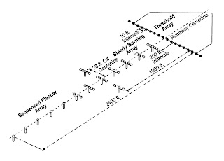
    That's the concept. Here's the reality: multiple ultra-powerful strobe lights mounted high on poles spaced even distances apart, flashing endlessly in rhythm every time the weather goes to pot. Each light structure has multiple bulbs, with each single bulb powerful enough to light up several football fields.

    The lights do point up into the sky and when it's clear they have nothing to reflect them back to the ground. However, when the fog or the rain comes in, the lights reflect off the mist creating an effect akin to repetitive lightning bolts.

    Now, imagine if these lights were only a few hundred feet from your house. Actually, I'll imagine it for you. Here's an animation of what it looks when I drive past there at night when it's IFR:


    You've already got noise and pollution. Now when you're trying to settle in to read a book on a stormy night, your windows are flashing like a nightclub lighting system on speed. Time to get some hotel-style "blackout curtains" I guess....
The Future

Now, what's in store for our intrepid homeowners? When I typed "Pensacola Airport Master Plan" into Google, it brought me to this page.

The two links on the top of the page discuss development within the airport's existing footprint. Both do not seem to affect the surrounding communities too much in their effort to improve the airport's facilities.
However, the red flag went up when I saw the link on the left labelled "Land Acquisition Program". If you're not familiar with the concept of eminent domain, it's time to look it up. Basically, the government has the right to take private property and use it for its own purposes. Normally this is used for public works projects, such as utilities, highways, and railroads. If the government decides it wants to run a highway over your house, it has every right to do so as long as it provides fair compensation for your property. Unfortunately for the homeowners, "fair compensation" is usually a lot less than what they were hoping for since, for all intents and purposes, their home is condemned.

The intent here is to build an Commerce Park that serves the airport. What's interesting is that Pensacola Airport has decided to be civil about it and is making it a voluntary process. Instead of tearing people's houses out from under them, they're letting the owners sell them on their own terms. Rather than grab all that real estate, it's being sold to the airport's owners one lot at a time.

How does this affect the house in question? According to the map of properties, this commerce park is just to the northwest of the airport, cornered by Tippin and Langley Avenues. This map also shows you which properties have already been purchased.

Where does the house lie?
Yup - it's just as close to the airport as the land being redeveloped. Based on what I'm seeing, I'm going to make an educated guess and say that within 5 or 10 years, the updated Airport Master Plan will have a provision for purchasing those lots to the northeast of the airport as well. I hope the new homeowners don't plan on staying there too long.

What Will Be

Buying a house is all about the potential of the space you're purchasing. Usually that means things like laying pretty wood laminate over that old vinyl floor, putting in new appliances while tossing out the old ratty ones, or simply putting up a new coat of paint to replace that nasty wallpaper. In a larger scope, you take a look at the neighborhood to see if your neighbors really take care of their houses and what kinds of developments are going on around you. Most people do that before they take the plunge, since they want to know what they're getting into.

But if you're buying near an airport, you owe it to yourself to protect your investment and research as much as you can. Pull your view even further back and look at your city's infrastructure as a whole to see how it could change over the next few years. Obviously the airport is a major part of that, but other public works projects like highways and utilities should be watched as well. Don't get trapped in a house that's both uncomfortable to live in and impossible to sell because you didn't take into account what the city had been planning for years.

Saturday, March 01, 2008

Musical Journeys

As I explained a while ago, I don't listen to the radio anymore. I go mostly for independent artists and, in general, music that's off the beaten path and remains raw and mostly untouched by the distortion of record corporation hands. My search for new music feels at times like a journey around the world as I discover new artists, new instruments, and new sounds from man different places.

Here are some of the artists that have been making their way on to my MP3 player. Warning: acquired tastes ahead. :)

Asian Dub Foundation
Our first stop takes us to England. This band has so many interesting elements and influences it's hard to categorize. Musically, they blend reggae, dub, electronica, breakbeats, ambient music, punk rock, folk music, and ethnic instrumentation. Lyrically, I feel they're almost on par with the cutting socio-economic and cultural commentary of Rage Against the Machine. And their basslines... man, I wish I could write basslines as groovy and melodic as theirs.
Rachid Taha
Now we cross the Mediterranean to Algeria. In an age where the popular media associates anything Muslim with terrorism and fundamentalism, here you have an artist that sings in Arabic about democracy, altruism, and religious tolerance. Taha's music is based off of traditional Raï music, but it incorporates modern instrumentation and rock/hip-hop styles to create something unique. If you've seen the movie Black Hawk Down you've heard his song "Barra Barra" as it plays near the beginning of the film as the U.S. forces are after the informant's convoy.
  • Barra Barra: Video / Translation- Live version of the song from BHD, which is a song about the effects of war and famine on a civilian populace. The word "barra" means "outside".
  • Ya Rayah: Music Video / Live video / Translation - A modernized version of a traditional folk song about the homesickness immigrants feel for their homeland.
  • Rock El Casbah: Video / Translation- Live cover of the Clash classic, including the Clash's guitar player
Musical Trivia: In the first two videos, the 8 string guitar-like instrument played by the guy standing stage-left is an Oud, a relative of the European lute. The hand-drum played by the sitting percussionist, also on stage-left, is a Doumbek (a variant of the goblet drum).

Nujabes
Mount Fuji's in the distance, so we must be in Japan now, home of this downtempo hip hop artist. He's most known in the states for the soundtrack to the excellent anime Samurai Champloo. The genre is "downtempo hip-hop" - basically, music with a nice beat that's easy to chill out to. Whether you're working, cooking, or whatever, his instrumentals and occasional vocal tracks make for some mood-enhancing background music.
  • Song of Seasons: Video - The end theme of Samurai Champloo. I love the flowing bassline in this song.
  • Feather: Video - A slideshow of Japan to his music.
  • Luv Sic: Video - Another slideshow set to his music.
Yoko Kanno
Yoko Kanno is one of the premier television and film composers in Japan today, with her talents for creating audio soundscapes in high demand. In the states, she's known mostly for her amazing soundtrack work for anime series such as Ghost in the Shell, Cowboy Bebop, Macross Plus, and Vision of Escaflowne. Whereas traditional composers such as John Williams and James Horner use mainly conventional orchestras to create their film scores (mind you, to great effect), Kanno uses anything and everything. In one soundtrack, she'll have pounding industrial anthems, gentle ballads, funky pop, militaristic themes, dynamic electronica, murderous fear music, and orchestral compositions. There's simply nothing the woman can't do well.

  • Rise: Video - The theme from Ghost in the Shell: Stand Alone Complex Season 2.
  • Inner Universe: Video - The theme from Ghost in the Shell: Stand Alone Complex Season 2.
VAST
We've crossed the Pacific and gone "feet dry" over the western United States. Jon Crosby formed his band VAST in the late 90's and had a couple singles make it onto the radio: "Touched" and "Pretty When you Cry". However, he fought with his parent company over his 2nd album's musical direction and was subsequently dropped from the record label after its successful release.
Stories like his are the reason I don't listen to the "compose by committee and focus group" music that's on the radio today. He dropped off the music industry's radar, but has continued to release new music under his own record label.
  • Touched: Video
  • Pretty When You Cry: Video - One of the creepiest videos I've seen in a while...
  • Free: Video
  • Take Me With You: Video - A happy cheery song. :)
  • Thrown Away: Video - LOL, he's packed on the pounds since his earlier stuff.

KHZ
Coming into land in New York City (hopefully La Guardia's got an arrival slot), here's a band that I've been following for a while.
They combine two of my favorite things: industrial rock music and a seductive female singer. :)

Thursday, February 28, 2008

Hotdogging

One of the controllers I work with is an avid skydiver and skydiving instructor. He's taken tons of people for tandem dives, giving them their first exposure to the fine art of throwing yourself out of a perfectly good airplane. :)

Well, he decided it was time for his dog to earn his wings! Check this out:

Monday, February 25, 2008

Tight Quarters

"Space is big. You just won't believe how vastly, hugely, mind-bogglingly big it is. I mean, you may think it's a long way down the road to the drug store, but that's just peanuts to space. "
- The Late Douglas Adams

One may think the same about the sky. Look up at it and you'll see a blue infinity with no boundaries, no barriers - just emptiness. Maybe a bird or two looking for an unwitting target for their digestive pyrotechnics, maybe a small cloud that wants to go grow up one day to be a huge cumulonimbus. Typically, though, it's a vast expanse of nothing but air.

However... throw a few planes in there and start looking at it through a radar scope, and things will change quite a bit. Then add a few more planes in there and point them at the first batch of planes. Finally... put imaginary walls up and try to keep those airplanes from smacking into those walls without permission. Now we're having fun!

We have nine sectors at our facility, the smallest of which - the "Z" sector - is approximately 10 miles by 10 miles wide (at its widest point) and reaches from the surface to a mere 3000 feet. It also has a corridor starting at about 3.5 miles wide that extends to the northeast directly into Eglin Air Force Base's airspace. The sector is designed to serve South Whiting Naval Air Station, otherwise known as one of the U.S. Navy's largest helicopter training bases.

While we do have other sectors that are about as small, those are only used for arrival sequencing into our other two airports. This is the only one that's consistently used for both arrivals and departures.

Here's what it looks like:


This sector can get very busy with IFR and VFR traffic arriving and departing South Whiting as well as multiple VFR aircraft operating out of Milton airport, right in the middle of the sector. Also, a majority of the Navy aircraft want multiple practice approaches to runway 32.

I created an illustration showing a fairly busy session on "the Z". Each circle represents the 3 mile wide circle around an aircraft, and each color is a different altitude: 3000 feet is pink, blue is 2200 feet, and 1700 is green.

Note: While the two "blue" VFR aircraft don't technically require the 3 miles, I left the circles around them so they're easier to see.


It's really interesting working this sector. While you deal with the same factors you deal with in other sectors - altitude, sequencing, approaches, etc. - you've got a lot less room to work with.

  • Altitude: The ceiling is a stratospheric 3000 feet and our MVA is barely over a thousand feet below it at 1700. When you're dealing with IFR aircraft, that means you only have have those two altitudes available if you want to maintain your 1000 foot vertical separation. If you have VFR aircraft, you've got a third for them: 2200.

    As with everything in ATC, you need to plan accordingly and use your "tools" wisely. As an example, inbound aircraft heading southwest will typically be handed off at 4000 feet, while your northeast outbounds will want to climb to 3000 or 5000. If you don't get your outbound climbing and your inbound descending quickly enough, they could feasibly fly into each other's face.

  • Lateral Separation: The main block of airspace is 10 miles at its widest point, and the "neck" stretching to the northeast is a little over 3 miles wide at its narrowest point. In short, you've got very little wiggle room for lateral separation. However, being that we're a terminal facility, we get to take advantage of terminal course divergence rules:

    5-5-7. PASSING OR DIVERGING

    a. TERMINAL. In accordance with the following criteria, all other approved separation may be discontinued, and passing or diverging separation applied when:

    1. Aircraft are on opposite/reciprocal courses and you have observed that they have passed each other; or aircraft are on same or crossing courses and one aircraft has crossed the projected course of the other and the angular difference between their courses is at least 15 degrees.

    2. The tracks are monitored to ensure that the primary targets, beacon control slashes, or full digital terminal system primary and/or beacon target symbols will not touch
    .

    In short: as long as the route of one aircraft is guaranteed to pass behind another or both aircraft have courses diverging by 15 degrees or more, we can have less than 3 miles of separation. Our friends over at the En Route Centers don't have that luxury.

  • Approach Requests: South Whiting is one of the two most-used airfields in our airspace for practice approaches. Its primary runway has ILS, GPS, RNAV, TACAN, PAR, and ASR approaches available for use by the South Whiting-based helicopters and the fixed-wing T-34s out of North Whiting. What's good about this is that it familiarizes you with the idiosyncrasies for each type of approach.

    You also learn to manage dissimilar aircraft in tight quarters using speed control and sequencing. For example: if you've got a helo 10 flying miles from the runway and a T-34 15 flying miles away, who will be first? Well, the helo tops out at about 100 knots whereas the T-34 cruises at about 180. It then becomes simple mathematics: while the T-34 has 50% more distance to fly, it's going 80% faster.

  • Frequency Management: The PAR and ASR approaches are two types of Ground Controlled Approaches (GCAs) both of which require an aircraft to be "talked down" to the runway by a Navy ground controller. Basically, they make a transmission every few seconds (5 for PAR, 15 for ASR) that fine tunes the aircraft's approach. I don't know the exact phraseology, but it's along the lines of "You're left of final... You're right of final... You're on course." The main difference between two is that ASR provides only lateral corrections, while PAR does both vertical and lateral. It's so accurate that a good PAR/ASR controller can talk a plane down in nearly any kind of weather conditions.

    Now, we obviously can't have a GCA controller talking on our main frequency for 2 minutes straight every 5 seconds. Therefore, when an aircraft comes in for a GCA we assign them one of 4 GCA-only frequencies that are used only for approach purposes. This becomes a complication when you have more than 4 aircraft coming in for GCA approaches. Now you need to keep track of who's on what freq, which freqs have cleared now that an aircraft has landed, who's not going to need a freq anymore because they're done with their GCA practice, and who hasn't been assigned a button yet.

    I won't go into the specifics, but suffice it to say it takes a combination of accurate stripmarking, datablock scratchpad entries, and situational awareness to keep things straight.

  • Borrowed Airspace: If you notice on the sector map, there are three areas to the southeast that are not shaded in yellow. These areas are owned by Eglin AFB, our eastern neighbor, but are usually on loan to us. However, they'll take them back several times a day and apply different separation rules to them. The most troublesome is the hot boundary. Translation: they'll be running IFR aircraft inside those airspace blocks right up to the boundary, so we need to keep our IFR aircraft a minimum of 3 miles away from the boundary instead of the usual 1.5. VFR aircraft are unaffected and can run right up to the boundary.

    Those areas are only given to us up to 3000 feet. If you've got an inbound from the northeast at 4000 feet who needs to go south to get to the final, you need to make sure he's at or below 3000 feet when he crosses that line into those areas. If he descends too slowly and crosses that boundary at 3500, you've just had a deal.

  • Hot Boundaries: Now go back and look at the map. You'll see that Whiting's runway final depiction runs right into those areas I just mentioned. However, the approaches are designed to have a dogleg that runs nearly north/south, starting about 5 miles out from the airport. But...that dogleg is less than a mile from the boundary!

    What this boils down to is that we cannot give IFR aircraft any approaches if the boundary is hot. We usually have to tell the pilot something along the lines of "Navy123, the restricted areas have gone active. In order to continue with this practice approach you will need to cancel IFR." The Navy pilots are familiar with this situation and will usually comply. The weather around here is typically good and it's usually a non-issue.

    As a contingency - in the case of a combination of true IFR conditions and a hot boundary - we do have a separate helicopter-only TACAN approach that runs north/south a mile west of Milton airport. The fixed wing aircraft have their own full TACAN at North Whiting.

  • VFR Pop-ups: Milton is a very busy little uncontrolled training airport, to the point that on some days we feel like calling ourselves "Milton Approach". Overall, the Cessnas and Pipers that come off there are pretty innocuous and they usually take care of themselves. We issue traffic calls and altitude restrictions as needed to keep them informed of the swarm of Navy traffic around them, but they pretty much stay out of trouble.
  • My one pet peeve is the following: inevitably, when I've got a busy pattern full of Navy helos and T-34s, a student pilot will call up, "Pensacola... approach....Warrior 1...2..3...4........5... Off Milton at.... 1000 feet... uh...Five miles south of... uh....Milton. Request....requesting flight following to... the beach... the beach practice area."

    Now, I'm a pretty fresh private pilot. Mic fright sucks. I've had it. I still have it. I can relate and I'm in no way angry at them. But man... they always pick the worst possible time to call! However, considering the tight nature of the sector, by the time they're done one Navy guy's blown through final, another Navy guy's missed his turn, and yet another's about to run into another sector. Now I'm playing catch-up, calling out point-outs to other sectors and Eglin, and the whole plan needs to readjusted.
Overall, a lot can happen in a little bit of airspace. I'm sure there are hundreds of other sectors like this out there in other facilities. However, it was a pretty blunt shock coming from the Academy - where you've got all of two massive sectors 50 miles wide - to working a crowded piece of airspace that's about as big as my backyard. :)

Of the three sectors I'm training on, it's physically the smallest but by far the most challenging. But when you get it running smoothly, it feels really good.

Thursday, February 21, 2008

Eagles Down

This happened right next door to us:

Air Force: 1 pilot dies, another survives after F15Cs collide

The initial report we got was that one of our T-6 Texan II's from NAS Pensacola went down. We work with the T-6 students and instructors every day, so we were pretty worried when we heard this. There was a lot of Coast Guard activity and SAR stuff going out there.

Turns out that, instead, it was two USAF F-15's from our neighbors at Eglin AFB. I'm bummed that one of the pilots didn't make it.

It reminded me of this video I saw on YouTube a while ago, which is pretty freakin' scary. Both of these pilots survived:

Tuesday, January 22, 2008

Life on Data

I got checked out on Flight Data 1 & 2 a couple weeks ago.

Flight Data seems to be where most people start out in most facilities. Here, I started on radar first and then trained on flight data several times a week in between radar sessions. I don't think there's anything wrong with either approach, since they compliment each other. Working radar teaches you the operation and how everything fits together, plus allows you to see why you need to do certain things when you're working Data.

Flight Data always gets treated condescendingly as a position. You don't talk to any airplanes and you're basically doing the "paperwork" for everyone else who is talking to airplanes. However, it's a vital position that is designed to allow those working radar to focus on their traffic rather than dealing with weather data and NOTAMs.

Now, doing a good job on flight data will not actively relieve the stress of the different radar positions. However doing a bad job will complicate the rest of the room and pour on the stress.

One of my coworkers put it quite eloquently, "On flight data, you can't keep the room from going down the shitter, but you can sure send it there in a hurry!" :)

For those that don't know, the basic role of Flight Data is to:
  • Run flight data strips to different positions.
  • Update the weather and information displays.
  • Correct and follow-up on defective flight plans.
  • Amend, create, and remove flight plans.
  • Collecting traffic strips and papers for counting.
Here's a quick overview of how it works:

1) Departing Aircraft:

We have three Class C airports within our airspace, and we maintain a separate strip bay for each to keep things organized. When a particular aircraft is on the move, the tower will call our Flight Data position to activate the aircraft. We then take the strip(s) to the appropriate scope working that airport so they have it in front of them.

2) Arriving or En Route Aircraft:

For aircraft transiting or landing in our airspace, we'll post the strip in the strip bay next to the radar scope sorted by the time they're supposed to arrive in our air space. Sounds easy, right? Not necessarily. There's a lot of "educated guesstimation" going on there. You have to be very aware of your airspace, your operations, your letters of agreement, and the positions that are open.

Here's an example:


Call sign: Navy 123
Type: T-1 Jayhawk
Departed: Naval Air Station Jacksonville
Arrival Fix: Crestview VOR
Destination: Naval Air Station Pensacola
Direction of flight: Southwest
Arrival Time: 0800
Call sign: Navy 456
Type: T-6 Texan II
Departed: Naval Air Station Jacksonville
Arrival Fix: Crestview VOR
Destination: Naval Air Station Pensacola
Direction of flight: Southwest
Arrival Time: 0800

Aside from the type of aircraft, both are identical right? Both strips will show the same thing, the same fix, same destination, etc. However... the type of aircraft changes everything; the T-6's are turboprop trainers, the T-1's are jets. Per our Letters of Agreement (LOAs), Navy jets always come in high, overfly the rest of our airspace, and go direct to the NAS Pensacola sector. The props always come in lower and have to go through our other sectors before eventually arriving at NAS Pensacola.

So, as far as strip posting for our example, Navy 123 would go directly to the NAS Pensacola sector. On the other hand, the Navy 456 would go to our lower-altitude East sector.

Basically, the devil is in the details. After a while, you're able to look at a strip and quickly determine where it's going and get it there. You'll recognize patterns that will make things second nature. However, even after a while, there are still strips - usually unscheduled GA traffic whose course puts them right on the line between several sectors - where you'll have no idea as to where they'll go. In those cases, you just take your best guess and post it on the scope where it's most likely to go. Even then, you've got about a 50/50 chance of hearing someone call out "Anybody got a strip on a N12345?" :)

3) Flight Plan Management

ATC is a dynamic operation and all things are subject to change, including what's written on a flight strip. Reasons for modifications are numerous:
  • Modifying an en route aircraft's altitude so that the receiving facility knows what altitude to expect him at.
  • Adding a fix in other facility's airspace to a flight plan so that it will hand off to that facility correctly.
  • When an aircraft whose flight plan takes it to another facility decides to cancel radar services, you'll need to "Remove strips" on that aircraft. This deletes the flight plan from the National Airspace System and informs any facilities along his route of flight to throw away all strips related to that aircraft. If you don't remove the strips on that aircraft, you'll be getting phone calls asking about that airplane wondering where he is and if anything happened to him.
Working on Flight Data, you'll find out really quickly that our National Airspace System has tons of quirks. It's very, very particular about how it wants its information, and even when you input it correctly there will invariably be moments when you are staring at the screen, looking at the feedback, saying to yourself "What the hell?"

My one word of advice: Whenever you go Oklahoma City to train, become real familiar with the FDIO (Flight Data Input-Output computer). Pay attention during that lesson. Learn the fields and learn the formats for amendments, because you will be using them frequently.

4) Weather and Information

The last of your major duties is to - put simply - disseminate information of all kinds related to the operation and update the information on this screen. There's one of these screens over each radar scope and from the Flight Data position you can update the data on all of them simultaneously.

(BTW, check out that low ceiling!)

Typical information:
  • Weather/ATIS: While our main airport updates its weather and ATIS automatically, we get manually-sent weather reports from the other two Class C's in our airspace. This gets a funky sometimes because the airport's weather department will send you new weather but the tower will still be using the old ATIS code. We have in-house procedures for when that happens - namely putting a highly advanced asterisk next to the ATIS code when the ATIS is old but the weather is new. :)
  • MOA Activations: When areas go hot, it affects our routes and approaches, so it's vital to get that info up there.
  • NOTAMs: Various NOTAMs for both towered and uncontrolled fields throughout our airspace. Examples include unavailable approaches, closed runways, lighting outages, and navigation aid outages.
  • Flow Control: Our flow with our two neighboring centers and two approach controls changes frequently, so that needs to be updated. We have two main settings: Gates and Randoms. Gates means that aircraft going to another facility need to be routed through one of our arrival/departure gates. Randoms means you can put the aircraft through any part of the airspace boundary between both facilities.
Well, that's an overview of Flight Data. It's one of those positions where you'll have your feet up one second, and the next you'll be literally breaking a sweat as you're running strips all over the room, inputing amendments shouted at you from around the room, and stuffing piles of strips coming out of the printer. Not very glamorous, but certainly very important to the operation.

Thursday, January 17, 2008

Back from the dead

I'm really sorry I haven't posted in a while. Believe me, it's not for lack of material. I've just had a lot going on in my life over the past month or so,.

Here's the breakdown:
  • We finally found a house we wanted to buy, after 8 months of searching.
  • We had to jump through an enormous number of hoops to get this house. It's our first home, so all of the inspections, the paperwork, shopping for mortgages, comparing insurance companies, etc were new to us and very tiring.
  • We had to pack up everything in the apartment we'd been renting.
  • The holidays came and went, bringing along with them their own set of complications, as we went back to Miami to visit our families.
  • We closed on the house on Dec. 28th.
  • We moved into the house over the weekend before New Year's.
  • Every bit of free time we've had since we got the house has been spent working on getting the house setup as we want it. New appliances, new furniture, etc.
  • I've been setting up a garage work shop so I can Do-It-Yourself things around the house. I bought all kinds of dangerous toys like saws, drills, and Dremel tools. :)
  • On top of that, we had no internet for several weeks, and I can't access Blogger from work.
I gotta say, it's wonderful being able to own your home and not throw away money in rent. We were very lucky in being sent to Pensacola. I've heard horror stories from friends of mine who were sent to places like Nantucket and Southern California and are trying to get by on the AG payscale. Not one of them has been able to survive without help from their families. For several of them, 75% of their salary goes to just rent. If you're taking home $2300 a month ( AG salary including standard 12.52% locality), and your rent is $1600, there's simply not much breathing room for car payments, insurance, utilities, phone, car, food etc..

Down here, home prices are excellent compared to what I'm used to. In Miami, a comparable house to the one we bought would have been priced three or four times as much. We simply would not have been able to afford anything.

Put it this way: my best friend in Miami recently bought a 1/1 apartment in an older condo-conversion subdivision in a mediocre area of town. It's around 600-700 square feet, has a dinky kitchen, and was in fixer-upper condition. He had to put in a lot of money into updating the bathroom and living room, and the place still looks kind of dreary.

Our house is a 3 bed/2 bath detached single family home with 1620 square feet, a 2 car garage, and a huge corner lot. We have a covered porch, 15 foot high ceilings, a beautiful kitchen, and tons of storage. Our neighborhood is very pretty and quiet, with lots of kids and people out jogging. We're 10 minutes from my work and 15 from Mary's, and if you sit out on the front porch you can watch the approach traffic on the glide path into our main runway, beautifully lit by the afternoon sun.

The kicker? We paid $20,000 less than my friend did for his 1/1 condo.

On top of that, we have no traffic jams here, people are very nice, everything is close, and the city is overall very pleasant. The nightlife is no South Beach, but at the same time everyone here is more down to Earth and real. There's plenty to do and see. Whenever we have kid(s), the schools here are some of the best in the state.

The moral of the story is this: if the FAA assigns you to some strange airport in the state of your choice, do your research. Visit the city, visit the facility, familiarize yourself. Don't blow it off. What you think may be some podunk tower in some backwater town may just be exactly what you've been seeking. I would never have thought I would like Pensacola, but I find that I'm really liking the way of life down here.

Saturday, December 08, 2007

Living History

I love airplanes. I enjoy seeing them, reading about them, flying them, visiting a museum full of them, and generally being around them. No matter the shape, size, purpose, or model, I'm a fan. One of these years I'd maybe like to own one, like a sporty Vans RV series (200mph + full aerobatics = wooHOO!) or even something as basic as a Cessna 172. But that's far into the future.

As I train, I'm of course talking to a variety of aircraft on a daily basis. Since the sectors I'm training on are low altitude (surface to 5500') all of the airliners, corporate planes, and jets pass overhead at 6000-10000. The majority of aircraft I work are Navy T-34s and H-47s, plus a few Cessnas and Pipers. We also get the Navajos, the Cirrus, the occasional Columbia, and other GA types that are passing through. I've talked to enough of these that, while not exactly "routine", they've become "regulars" whose patterns you recognize well.

However, every once in a while, I'll talk to an aircraft that'll bring out the airplane fan in me and put a smile on my face.

Two days ago, I was handed a strip for a N18P. He was traveling eastbound and I didn't recognize the aircraft type. "AA5" or something like that. I take the handoff and see that he's cruising at 200+ knots. He checks on, I give him the altimeter, and ask him his aircraft type.

He responds "Grumman FM-2 Wildcat".

A little history lesson: The Wildcat is a WWII aircraft carrier fighter that was featured in every theatre of the war - Pacific, North Atlantic, European, etc.. It was not the fastest, nor the most maneuverable, nor the most heavily armed fighter of the war. Its opponents like the Japanese Zero were much more maneuverable. It is often forgotten in lieu of flashier aircraft like the P-51 Mustang or the P-38 Lightning. Compared to the sleek F-4U Corsair or the massive P-47 Thunderbolt, it's a tubby little barrel of an airplane.

However, it is the quintessential "unsung hero" of the war, especially the war in the Pacific. In the battles of Midway, Coral Sea, Santa Cruz, and others, it protected American dive dombers and torpedo planes as they struck again and again at the Japanese naval fleet. In the Atlantic, it served aboard light escort carriers, conducting patrols and protecting convoys from the ubiquitous German U-boat threat and German airpower. In England, it became the first American-built aircraft in British service to score a combat kill.

The Wildcat had a large list of pros and cons. The Wildcat's hand-cranked, narrow-track landing gear made carrier operations very treacherous. On the other hand, while outperformed by the Zero, it could take far more damage thanks to its construction and self-sealing fuel tanks. Zero pilots could pour hundreds of rounds into a Wildcat and still not bring it down, whereas a few shots into a Zero would cause it to burst into flame. The Wildcat was simply able to bring its pilots home safely. As an example of the overall success of the design, Wildcat variants were produced from 1940 up until the final days of the Pacific war, even after more powerful replacement aircraft such as the F6F Hellcat had been introduced.

I had no other traffic at that point, so I talked with the pilot a few times. "Is that the one with the hand-cranked landing gear?" I could hear him perk up when he realized I knew exactly what he was flying. "Sure is!." I found out he was based at the Cavanaugh Flight Museum located in Texas. "Do you give rides?" I asked, hoping that maybe they'd modified it into a two seater like some P-51 owners had. "Only got one seat," he said, laughing. They apparently perform at air shows around the country. "I'd love to come here [Pensacola] for an air show," he said. "You're welcome anytime." I replied. He sounded like he was having a great time in that war bird. Eventually, I handed him off to Eglin AFB's controllers with a parting "Have a great flight."

It was just cool. I really enjoy history, and definitely appreciate the efforts of those who want to keep history alive. It's one thing to see a photo on the web or words in a book. It's quite another to see the real thing, engine roaring, pilot lifting it into the sky, giving modern audiences a taste of what aviation was like back then. Even when the folks who flew them into battle are gone, at least we'll have their machines to bring those lost stories to life for generations to come.

Some pics of the Wildcat, then and now.

Wildcat taking off from the USS Ranger.
Wildcat formation.

N18P taxiing.
N18P in flight.

Sunday, November 25, 2007

Blue Angels Video 2007

Here's the video I shot at the Blue Angels homecoming air show a couple of weeks back. I finally got around to putting it up on YouTube. I show some highlights from the show, and finish up with the Blues.

Enjoy!


A few words on the music: it's the song "We Rise" by Chris Corner and is from the soundtrack to the 2005 French movie Les Chevaliers du Ciel, or "Knights of the Sky". It's basically a French version of Top Gun, with an equally corny plot, Mirage 2000s instead of F-14 Tomcats, and a couple of goofy looking pilot dudes that make Goose look like a tough guy. It's not exactly Oscar caliber material.

However... the cinematography is absolutely incredible. All of the in-flight shots are actual aircraft - no special effects or computer generated imagery. They built a special camera pod and strapped it on to a Mirage, so that it could follow the other Mirages through numerous maneuvers. There's dogfights over mountains, low level flying over deserts, shots over water, mock combat in the clouds... and it all looks beautiful.

Here's a video somebody cut together of some of the flying scenes in the movie. Remember: this is all real. No special effects, no movie magic.


I don't care who you are, that's just some beautiful footage right there.

Saturday, November 24, 2007

Excitebus

Remember that old Nintendo game Excitebike? The one where you raced down a track at full speed, racing other bikers and jumping some insane obstacles?


Looks like someone tried that with an Airbus A340-600.... and failed.

They were apparently doing a pre-delivery full power runup at the Airbus facility when the aircraft broke free and slammed into a blast wall. No word yet on whether it was a brake failure, a restraint failure, or something else.

Unfortunately, 10 people were injured and the plane appears to be a writeoff. Thankfully, no one was killed, which was helped - I'm sure - by the fact that the blast wall was angled. If it had been a vertical wall, things would have been a lot worse for those aboard.

Read the A-NN Article

Wednesday, November 21, 2007

Multi-tasking

Someone asked me this recently: How much paperwork/busywork do you need to do when you're on position?

Firstly, none of it is "busywork". Everything you do has a purpose. Secondly, you do a lot more than just sit there and talk to airplanes. Between stripmarking , ARTS command entries, inter-facility coordination, and intra-facility coordination, you've got a lot to do. The faster you get it done, the better off you'll be. I've actually found the off-frequency work to be one of the biggest challenges I've faced.

Let's run through a very simple morning session at Whiting NAS to the northeast of Pensacola. To start, let me give you some visual aids. As always, you can click a pic to blow it up larger.

Airspace: The area outlined in orange is the sector I've been training on. Depending on the workload, it can be split up into three scopes - the D (departures from NSE), the K (arrivals into NSE), and the Z (arrivals/departures from NDZ). But for the purposes of this blog post, let's assume the workload is relatively light and everything in there is combined up as one big sector.


The aircraft featured are:

T-34C Mentor: The entirety of North Whiting's fleet is composed of these little guys. Based off of the Beech Bonanza, the first one of these guys first took flight in 1948 (!!!). The models they're flying now are updated turboprop "C" models such as this one, but they're still pretty darn old. They cruise around 210 knots or so, but are being replaced by T-6 Texan II's which can hit 310 knots at altitude. The T-34C in the photo is actually from Training Air Wing Five, which is the North Whiting training unit (it says TAW-5 right underneath the tail).


TH-57 Sea Ranger: The Bell 206 in yet another of its many guises. These are the helos out of South Whiting.


The format: Anything that's an action will be in bold, anything that's in yellow is a radio call, and anything in green is a land line call. Also, you'll see [initials] quite often. For those who don't know, every time you make a land line coordination, you're supposed to end it with your initials as a form of verbal signature.

The setup:
I've only got one plane on my scope right now, a T-34 - Red Knight 165 (RN165) - on a base leg to join a TACAN approach for Runway 14 into North Whiting.
  1. Me: "RN165, four miles from final approach fix, turn right heading 110, maintain 1700 until established on the final approach course, cleared TACAN Runway 14 approach. Circle to land runway 5."
  2. RN165: "[Reads back approach clearance.]"
  3. SH281, a VFR pop-up, checks in: "Pensacola Approach, Shooter 281, flight of two T-34s, over Brewton at 3500, with information Hotel."
  4. I look up at Brewton and see him up there at 3500.
  5. I type in "SH281" into the ARTS keyboard and press Enter. It generates a squawk code assigned to that callsign.
  6. Me: "SH281, Pensacola Approach, squawk 0101"
  7. I write SH281 on our traffic count pad, along with his arrival airport "NSE" = North Whiting..
  8. SH281: "Roger, SH281, squawking 0101."
  9. North Whiting tower calls on the shout line: "Departure, tower, non-tag, Blackbird 295." (A non-tag is an aircraft that's taken off without his transponder on or set to a wrong code)
  10. I spot the non-tagged primary target on my scope departing from the airport and observed it within 1 mile of the airport's departure end.
  11. Key up North Whiting tower's direct line.
  12. Me: "Blackbird 295, non-tag, [initials]" to acknowledge and unkey.
  13. I look up on my tab list of departing aircraft to see what code he should be on.
  14. Me: "Blackbird 295, Pensacola departure, radar contact. Check transponder on. Squawk 0142."
  15. BB295: "Pensacola departure, BB295, roger, radar contact. Recycling transponder. Squawk 0142."
  16. I observe SH281 has now popped up near his fix.
  17. Me: "SH281, radar contact 1 mile east of Brewton."
  18. SH281: "Roger, radar contact."
  19. I recall that SH281 is a flight of two. I type "H" and "M" and then click on SH281's target. This puts an "M" in the special modifier section of the datablock so that the tower will know that SH281 has Multiple aircraft.
  20. I observe that VV5E129 is flashing in my Activation List. He is the first one on the list, and therefore letter "A". Aircraft needing activation will typically be on specialized IFR or VFR flight plans and will have strips printed and ready for whenever they activate. Before they can take off, you need to activate their flight plans.
  21. I press the "F13" key, then "A", and press Enter. VV5E129 stops flashing.
  22. In front of me I have three columns of strips. To the far left are the unactivated "proposed" strips, to my immediate left are my activated strips, and to my immediate right are the aircraft that have actually taken off. I move VV5E129's now-activated strip over to my "activated" column of strips.
  23. I see that RN165 is established on the TACAN approach.
  24. Me: "RN165, contact North Whiting Tower."
  25. RN165: "Roger, RN165 switching."
  26. I observe BB295's callsign has popped up properly.
  27. Me: "BB295, Pensacola, transponder appears normal. Say altitude leaving."
  28. BB295: "Leaving 1100 for 4500, BB295."
  29. I verify that his Mode C readout is within 300 feet of what he's reporting.
  30. Me: "Roger."
  31. I observe that RN281, now well into his TACAN final, is getting a low-altitude alert (LA). Our regulations state that we need to inform Whiting tower of any LA alarms.
  32. I key up the Whiting Tower shout line.
  33. Me: "Tower, approach, low altitude alert, RN281, [initials]."
  34. Tower: "RN281, low-altitude alert, [initials]." and I unkey.
  35. I observe VV5E129 (the one I activated earlier) has departed North Whiting. I move VV5E129's strip to my "airborne" column. He is IFR and is requesting 5000 feet eastbound towards the Crestview VOR, and then on to Tallahassee. While most of my sector goes up to 5500 feet, the easternmost 5 miles of my sector only goes up to 3500. The airspace above (where VV5E129 needs to go) is owned by our "E" sector.
  36. I type "**E" and then slew and Enter on VV5E129. This action displays the aircraft on the "E" sector's scope.
  37. I key up the E sector on the landline.
  38. Me: "E, D, point-out."
  39. E: "E."
  40. Me: "1 mile north of Whiting, VV5E129, 5000, Crestview." That tells him:
    • Where he is now.
    • Who he is.
    • How high he wants to go.
    • Where he wants to go.
  41. E: (Scans for a moment) "VV5E129, point-out approved, [initials]."
  42. Me: "[initials]."
  43. I write "50" on VV5E129's strip.
  44. Crestview is located in Eglin Air Force Base's airspace. I type press they key with the triangle-shaped "Delta symbol" and "1", then click on VV5E129. This initiates the handoff to Eglin. A small "V" (for Eglin's identifier "VPS") appears in the datablock indicating the handoff is in progress.
  45. If I feel like it (and if my memory's feeling up to snuff) I file the strip in our completed flights pile. I already know where he's going, what altitude he's climbing to, and who he needs to talk to, so the strip is extraneous clutter at this point.
  46. In short: I handled all the coordination I needed to do before the aircraft even called me. That way:
    • I don't have to stop him at any interim altitude and can send him on his merry way.
    • The handoff's already been initiated, so I just need to wait for Eglin to take it. Then I can switch him at my leisure.
    • I don't have a useless strip distracting me 0n my desk.
  47. VV5E129: "Pensacola departure, VV5E129, climbing through 1200."
  48. Me: "VV5E129, Pensacola departure, climb and maintain 5000. Leaving 3000, turn right direct Crestview."
  49. VV5E129: "Roger, [reads back]."
  50. I observe that helicopter Lucky 082 (LY082)has departed South Whiting.
  51. I move LY082's strip over to my airborne column and see that Flight Data wrote that he wants to do multiple practice PAR approaches at South Whiting. PAR (Precision Approach Radar) approaches require a Navy "GCA" controller to talk the plane down to the runway, using voice commands. This requires special frequencies just for those operations. We have 5 of them which we call "Buttons", each with its own transmitter.
  52. Once again, I want to get ready before LY082 even calls me. I key up the Button 1 transmitter.
  53. I type "PS1" into LY082's scratchpad. P = PAR approach. S = Standard missed approach (since he'll be coming back to us for more approaches). 1 = the Button he's on.
  54. I write a big "1" on LY082's strip, as a secondary reminder of what Button he's on.
  55. I type "B" and click on LY082 to hand him off to the Navy final controller. PAR approaches require you to actually hand the aircraft off to the GCA controller. There, now he's completely cleaned up. All I need to do now is talk to him. :)
  56. LY082: "Pensacola departure, LY082, leaving 1100 for 1700."
  57. Me: "LY082, Pensacola departure, radar contact. Turn left heading 140, vectors PAR approach. Change to my frequency [Button 1 frequency]."
  58. LY082: "Roger, [read back]."
  59. Me: (After I've vectored him around the pattern and put him on a base leg) "LY082, 10 miles from Whiting, turn left heading 360, stand by final controller."
  60. LY082: "Left 360, standing by, LY082."
  61. I key up Whiting's GCA controller.
  62. Me: "GCA, Approach, Button 1, heading 360."
  63. GCA: "Button 1, 360, [initials]." He's already taken the handoff and sees the PS1 in the scratchpad, so he knows who I'm talking about.
  64. Me: "[initials]"
  65. I unkey GCA.
  66. I reach up and turn off the transmitter for Button 1. Otherwise, I'll be interfering with his PAR instructions whenever I transmit. GCA turns him on to the final.
  67. I see that VV5E129's only has a few miles to go before leaving my airspace, and that Eglin has taken the handoff.
  68. Me: "VV5E129, contact Eglin approach on [frequency]."
  69. VV5E129: "Switching to Eglin on [frequency], VV5E129."
  70. .... and the session continues ....
That's just with four aircraft. We've had it where we'll get the following simultaneously:
  • North Whiting launching a dozen T-34s going every which way, with half of them being non-tags that need to be deal with and the other half needing special instructions.
  • Groups of T-34s recovering from all directions to North Whiting, with many of them wanting something special for an approach.
  • Half a dozen helos and T-34s doing a roundy-round the GCA pattern down by South Whiting, requesting multiple PAR, ILS, ASR, or TACAN approaches.
  • Four or five VFR pop ups off of Milton wanting to go to various practice areas.
  • A dash of low-level GA departures out of the Pensacola East sector.
By then you've got yourself a party! If staffing isn't an issue, one or two of the other scopes will have been opened up to alleviate some of the workload.

Hopefully the above example makes some kind of sense and gives you an idea of the paperwork/coordination involved both within and outside the facility.

Saturday, November 10, 2007

The Blues

I went to the Blue Angels Homecoming Air Show today. Man, that was fun. I haven't seen the Blues perform since I was a kid, so it was great seeing them in action again.

Oh, and the "sneak pass" is still the absolute shizzle. That's where Blues 1 through 4 complete one of their formation maneuvers and start drifting off to the side. The announcer comes on, saying, "Watch how the foursome rearranges itself into the diamond formation..." Of course you're looking at the four fading off into the distance.

But then, right when you've been misdirected, a Blue Angel soloist comes hurtling down the runway opposite from where you're looking, afterburners on, startling the hell out of everyone. At the same time, the other Blue Angel soloist roars in from behind the crowd, over your head, kicking those involuntary "hit the deck" reflexes into gear. It drives everyone wild, especially if you've never seen it before.

Here's a YouTube vid of it from last year's show:


Anyways, it was a great show.

There were three aerobatic performances by Red-Bull Air Race-type aircraft, including an Extra 300L and an MX. Hammerhead stalls, wingovers, precision rolls, Immelmans, Cuban eights, and more were executed with extreme precision. However, my favorite aerobatic maneuver of them all is the Lomcevak, which is a Czech work that means "hangover".

Watch this video to see why:


I'd heard about that maneuver, but never seen it in person. As a pilot, it just makes me crazy. I mean, that's a little above and beyond unusual attitude training in a Cessna 172! :)

There were also a couple of military demonstrations from an F/A-18F and an F-16, which concluded in a very nice heritage flight with a P-51/F-16 combo. The F/A-18F is a sweet machine, much more impressive than its C-model predecessor, and the F-16 is certainly a treat to watch. However, having been to both the Paris and Farnborough air shows, I miss seeing the Sukhois and MiGs. For me, an air show is no longer complete without seeing at least a Pugachev cobra maneuver or a tail slide.

Picture Show

I shot nearly two hours worth of video, which I'll edit over the next couple of days down to a couple minutes of highlghts. In the meantime here's a few of the still pics I took around the show.

(Click each one to view it full-size)

Blue Angel Number 5: Engines are started and she's ready to roll. Her crew chief stands in front and a crewman kneels behind each wingtip.

Blue Angels Panorama: All six BA's lined up awaiting their pilots.
C-5 Galaxy: The world's largest umbrella.
T-6 Texan II: A very large percentage of our traffic consists of flocks of these little guys. It's a very powerful aircraft, with a top speed of over 300 knots and a 35,000 foot service ceiling. These guys can fly circles around the old T-34's they're replacing, which makes it really interesting when we get T-6's from NAS Pensacola in the same pattern as the T-34's from NAS Whiting.

Panavia Tornado: A very powerful swing-wing fighter-bomber flown by the United Kingdom, Germany, Italy, and Saudi Arabia. To quote the Volkswagen ad: "Representin' Deutschland, yo!"

Saturday, October 20, 2007

"Expect nothing...

...That way you'll be ready for anything."
- Takeshi Kovacs, Broken Angels by Richard Morgan

This a short tie-in with my last post, Learning on the Run.

A couple of weeks ago on a quiet IFR morning, my instructor was working the main Pensacola Regional airport sector, with all but 1 of the other sectors combined into it. All-told, it was about 3/4 of our entire facility's airspace. Whiting NAS, the scope bank all of my training had been on, wasn't open yet, so my instructor asked if I wanted to monitor while he worked. I said "sure", went out to grab my headset, came back in, and my instructor says "Okay, you're working the traffic."

So, there I was, working an airport I'd only studied, using approaches I'd never cleared anyone for before, giving vectors that I'd never used, and working real honest-to-God airliners loaded with lots of people on board. Obviously my instructor was plugged in with me and coaching me along, but it felt very strange at first. After a while I got a much better feel for the differences in speed and flow.

Here's a segment of the recording from that morning, off of LiveATC.net.

http://www.wickedpenguin.com/audio/First_Session_On_Sector_E.mp3

A couple notes:
  • If you're familiar with LiveATC, you know that a lot of their audio sources cycle between different frequencies at a facility. The feed for us cycles between our main Pensacola Regional airport sector, our Pensacola NAS sector, and the Pensacola Regional tower. I cut out the transmissions from the other sectors. That's why you'll never hear me clear some of the aircraft to land, as the feed had cycled to the other frequencies while I did that.
  • I trimmed all of the dead air out of it (if you like to listening silence, well, sorry).
  • The original recording takes place over about 30 minutes. We don't have that much traffic at that time of the morning, but because I cut out the dead air and the time spent on other frequencies it sounds a lot busier than it was.
The aircraft, in order of appearance:
  • Coast Guard Auxilliary
  • EGF855: American Eagle regional jet (probably an ERJ145 or CRJ200)
  • Citation 78CK: Cessna C550 corporate jet
  • Buck 312: Navy T-6 Texan II trainer
  • ASQ769 (pronounced "Acey"): Atlantic Southeast Airlines CRJ200
  • GFT9151: Gulfstream International Beech 1900
  • Flight Express 101: Cessna 210
  • Cirrus 38BK: Cirrus SR22

Learning on the Run

Before I came to Pensacola, I'd visited a few other facilities that were much newer than our 40+ year old building. While the STARS and ACD systems are nice and all, the one thing I'm really feeling is the lack of an honest-to-God simulator with our airspace.

I've said it before that simulators are no replacement for the real thing. However, I do strongly feel that simulators are very important for getting procedures and patterns down. They create an idealized environment where you can build habits and see how things flow. You can try things and experiment with no danger to anyone. Your instructor can freeze the problem and point out a possible conflict, and discuss possible courses of action. In addition, you're learning the airspace and the frequencies. They're great for getting the fundamentals down so you don't have to think about them anymore.

Going through RTF teaches you the basics of radar terminal control. Vectoring, speed control, approach clearances, etc. However, they use generic air space. Every ATC facility out there is unique and each has its quirks. It would have been nice to have some runs on a Pensacola-based simulator before getting on the real scopes, as there are certain operations here that are truly unique. It also lets you see potential problem areas in action. I've had more than one experienced CPC here tell me this is the most screwed up air space they've ever seen.

Unfortunately, we're not setup for simulation here. Whereas the folks at Miami Tower and Potomac TRACON can work simulated problems using their real airspace on ATC simulators, we train with live traffic. No ghost pilots, no "pause the problem" so you can work it out. The only time we can experiment is when traffic is very slow, allowing some breathing room so we can get a little more experimental with our vectors (I recommend not flying in our airspace when it's slow, LOL... just kidding).

So, while you're developing your stripmarking, your paperwork, your airspace and attempting to build your basic understanding, you're working with real people on the other end of the radio. The issue with that is that there's no control over what you get. ATC is a fluid business, and you are guaranteed at least one or two odd-ball requests every time you sit down... if you're lucky. Most often you'll have more. So, as opposed to a structured "curriculum" where you build certain skills over time, here you need to be ready for anything at any given moment. That's just the nature of ATC.

Real World Example

Let me give you an example, but first I'll explain a little about our operation: Nearly all of my training has been on the Whiting Naval Air Station bank of scopes. The fixed-wing aircraft from Whiting use what are called VFR course rules. Course rules are essentially highly "proceduralized" (is that a word?) flight plans that the training flights follow to get into and out of Whiting. On departure, they'll climb to a pre-determined altitude, turn to a pre-determined heading towards their practice area, and cancel flight following at a pre-determined point. They'll each have a specific pre-determined practice area (A1, A2, A2F, or A3) in their scratchpad, so you know exactly which course rule they're flying. When they come back, they'll call in over three possible pre-determined fixes at a pre-determined altitude, be issued a transponder code by you, fly a pre-determined route back into the airport, and switch to the tower over a pre-determined fix.

It's pretty predictable and usually works smoothly. I guess a parallel would be a SID or a STAR. The only real controlling you need to do (outside of handling specific requests for holding and practice approaches) is traffic calls and sequencing for arrivals that are arriving too close together.

All that goes out the window when the weather is IFR.... which is exactly what happened the other day when a massive front came through bringing all kinds of nastiness.

Departures: Due to the IFR weather, the course rules were completely unusable, so all of the procedures I'd been training with were worthless. For the departures, Whiting was launching every aircraft as a VFR-On-Top (OTP). This meant the following:
  1. They each had OTP in their scratchpad, so we didn't know which area they were heading towards.
  2. They were IFR, so we had to request a cancellation from each one.
  3. They were not following a course rules procedure, so once they cancelled IFR we had to:
    1. Ask each one "What's your working area?"
    2. Enter it into the scratchpad
    3. Issue them the appropriate heading and altitude for their working area so they wouldn't go wandering off randomly.
  4. Issue traffic and a flight following cancellation as usual.
  5. The only good thing is that, due to IFR separation rules, they were launching them with some more space between.
Arrivals: For the inbounds, all of these Whiting Navy trainers returning from their practice areas were requesting airborne IFR pick-ups for vectors to a TACAN approach into Whiting NAS. This complicates things on several levels:
  1. Firstly, I think I'd given maybe two of these types of clearances previously over the past month, and now I was giving them out left and right, vectoring on the fly.
  2. One of the major reporting points they call over is inside another sector. We have pre-arranged coordination with that sector so we don't need to call them with course rules Navy trainers that call in at the appropriate VFR altitude. However... the trainers were calling in at a variety of altitudes, so we had to coordinate and point out every one to the other sector.
  3. They were all "Cleared to Whiting via radar vectors" so I had to - as the clearance suggests - provide radar vectors to get them to the TACAN. It was excellent vectoring practice since they were coming from all over the place.
  4. With every aircraft requesting the same TACAN approach, now you've got a congestion problem that requires real sequencing and IFR altitude separation - 3 miles or 1000 feet. It really works your speed control and vectoring skills, plus your knowledge.
  5. In addition, I was working both the arrival and departure sectors combined. This meant that I had two frequencies open, and overlapping transmissions coming from both.
Now, there's nothing unusual about IFR departures and arrivals. There's a million of them everyday. However, when you're new to it, you're unsure of the phraseology, and you're dealing with them in large quantities, the comfort level and confidence level is a bit lower than it should be.

I kept up with it for a good while, but there came a point where I just fell behind. My instructor had to take over for a couple minutes as they were just calling in from everywhere. He told me after I took over again not to feel bad, which I really didn't. I was perfectly fine. I'd never worked any traffic like that in any great quantity, so I'm glad that I kept up with it as long as I could.

You have to step up to the plate and swing with all you've got at that moment, and I did. I have confidence that the next time this situation comes up I'll be ready for it. It was a hell of an interesting experience and I'm much better for it in the end.

Thursday, October 11, 2007

The Might and the Will

From the title of this post, maybe you're thinking this is a post about confidence or something like that. Actually, it's about lack of confidence or - to be more precise - certainty.

ATC deals in absolutes. When you have two aircraft pointed right at each other, you'd better be sure they're not going to smack. It's not "they probably won't hit" or "I think they should have separation."

A word that tends to fall right in front of the word separation in ATC texts is "ensure". Sometimes its preceded by the words "the controller failed to". Its our job to be absolutely, 100% positive that two aircraft will not come closer than is permitted.

Let's say you're sitting there working a sector and you see N123 and N456 coming together on a hazy morning. They're C172's and they're 10 miles apart at 120 knots, but they're both at 2000 feet on headings that will bring them together. When your instructor looks over your shoulder and asks you "Are those guys going to hit?" your answer cannot be "They probably won't." o

That's where the might and the will come into play. If they might have separation, but you're not sure they will have it, then you have to do something.

Now, what will that something be? Sure... you can wait until they're two miles apart and issue traffic in hopes of getting visual separation. If N123 does see N456 and reports him in sight, you can just tell him "Maintain visual separation from that traffic." But, once again, you'll be using the word might. You're placing a bet, taking a risk, praying that N123 can actually see N456.

But what if he doesn't? What if they're head-on and that other white Cessna is a white dot blending into the white haze? You'll be left with nothing but a tightening in your stomach and "panic vectors" that usually involve the word "immediately".

How could you have avoided this? Any number of ways:
  • "N123, climb and maintain 2500." There, now you have 500 feet of vertical separation.
  • Or... "N456, turn left 20 degrees for traffic." Great, now you've got divergence.
  • Or - legal but stupid - "N123, maintain at or below 80 knots" Now you've got a confused pilot slowing to approach speed at cruising altitude, but the speed differential will make N456 beat the other aircraft.
Any one of those simple things are sure-fire actions that will ensure separation. You've created the vertical separation, divergence, or speed difference necessary.

Let's say you issued one of the above instructions, such as the vertical separation. You could literally unplug, walk away, and be certain that they'll never hit. You could have been handed off those planes when they were 30 miles away from each other and never have to look at them again until it's time to hand them off to the next sector. Instead of focusing on them for all 30 miles, wondering if they'll hit, now you know for certain that they won't (as long as the pilots adhere to your instructions).

Remember Yoda in Empire Strikes Back? "Do or do not - there is no try"? In ATC the saying would be reworded as "They're going to hit or they aren't - there is no maybe."